Ultimate Bwindi Impenetrable Forest Map: Your Complete Guide to Gorilla Treks and Adventures
Bwindi Impenetrable Forest Map is the essential starting point for anyone planning to explore one of Africa’s most extraordinary natural wonders.
Nestled in southwestern Uganda, Bwindi Impenetrable National Park is a UNESCO World Heritage Site celebrated for its unmatched biodiversity and, most famously, as home to over 460 endangered mountain gorillas—nearly half of the world’s remaining population.
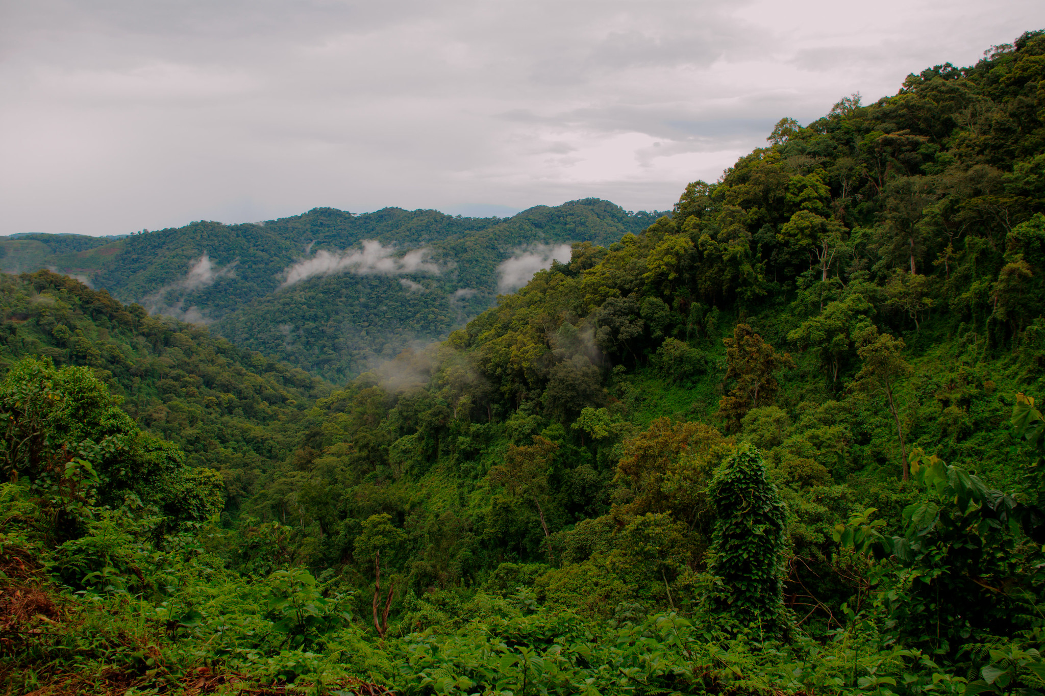
This ancient rainforest, estimated to be more than 25,000 years old, offers a rare blend of ecological richness, mist-covered hills, and life-changing wildlife encounters.
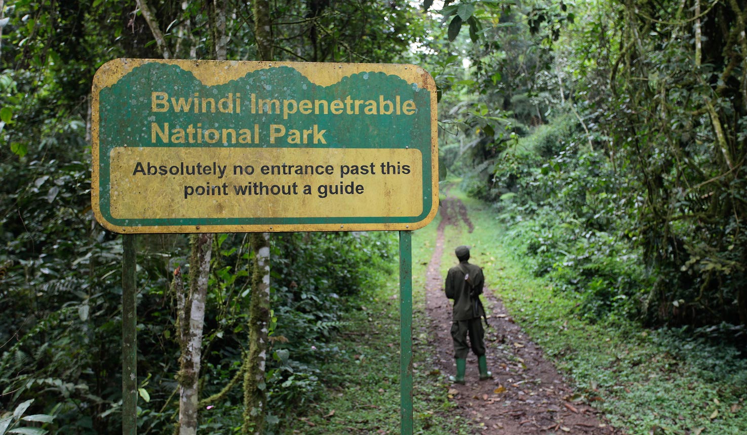
Covering approximately 321 km² of dense, rugged forest, Bwindi truly lives up to its name: “Impenetrable.” Thick vegetation, steep valleys, and limited road networks can make navigation challenging, even for experienced travelers.
That is where a detailed Bwindi Impenetrable Forest Map becomes invaluable.
Whether you are a first-time gorilla trekker, a seasoned safari guide, or a conservation researcher, the map helps you understand the park’s layout, trail systems, sector boundaries, and access points—saving time, improving safety, and enhancing your overall experience.
This map is more than just a navigation tool.
It highlights key gorilla trekking sectors such as Buhoma, Ruhija, Rushaga, and Nkuringo, major roads, ranger posts, nearby communities, and accommodation hubs.
It also provides context for elevation changes and terrain, which is critical when preparing for physically demanding gorilla treks in thick rainforest conditions.
In the sections ahead, you’ll discover how to read the map effectively, how it supports gorilla trekking planning, and why it is a must-have resource for visitors to Bwindi.
Download your free Bwindi Impenetrable Forest Map PDF today and plan your journey with confidence into Uganda’s most iconic rainforest.
History of Bwindi Impenetrable Forest
Bwindi Impenetrable Forest has a long and complex history that reflects both conservation progress and human impact.
Long before formal protection, this ancient rainforest served as a vital habitat for wildlife and as a home for indigenous forest communities.
Its dense vegetation, rugged terrain, and rich biodiversity made it one of East Africa’s most ecologically significant forests.
The modern conservation history of Bwindi began in 1932, when the British colonial administration designated parts of the forest as Crown Forest Reserves.
This move aimed to regulate timber extraction and protect water catchments, although controlled human use was still permitted.
By 1942, the area was formally consolidated and recognized as the Bwindi Impenetrable Forest Reserve, acknowledging its ecological importance and the need for stronger management.
A major turning point came in 1991, when Bwindi was upgraded to Bwindi Impenetrable National Park.
This new status provided the highest level of protection under Ugandan law and marked a shift from resource use to strict conservation.
The designation was driven largely by the urgent need to protect endangered mountain gorillas, whose survival was threatened by habitat loss, poaching, and human encroachment.
Gorilla tourism was later introduced as a conservation strategy, linking wildlife protection to local economic benefits.
In 1994, Bwindi gained global recognition when it was declared a UNESCO World Heritage Site.
UNESCO cited its exceptional biodiversity, ancient ecosystems, and role as a refuge for endangered species, including mountain gorillas, chimpanzees, and hundreds of bird species.
This status strengthened international support for conservation and research efforts within the park.
However, Bwindi’s conservation history also includes painful social consequences.
The Batwa people, indigenous hunter-gatherers who had lived in the forest for generations, were displaced during the creation of the national park.
Their eviction, carried out without adequate compensation or alternative livelihoods, remains one of the most debated aspects of Bwindi’s history.
In recent years, conservation has evolved to be more inclusive, with efforts to recognize Batwa cultural heritage, support community projects, and involve local people in tourism and conservation initiatives.
Today, Bwindi stands as a powerful example of how conservation has evolved—from colonial forest reserves to globally significant protected areas—while continuing to grapple with the need to balance environmental protection and social justice.
Key Historical Timeline
| Year | Event |
|---|---|
| 1932 | Designated as Crown Forest Reserves |
| 1942 | Bwindi Impenetrable Forest Reserve established |
| 1991 | Renamed Bwindi Impenetrable National Park |
| 1994 | Declared a UNESCO World Heritage Site |
Geography and Biodiversity of Bwindi Impenetrable Forest
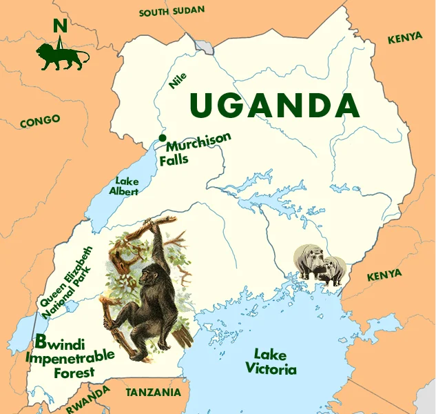
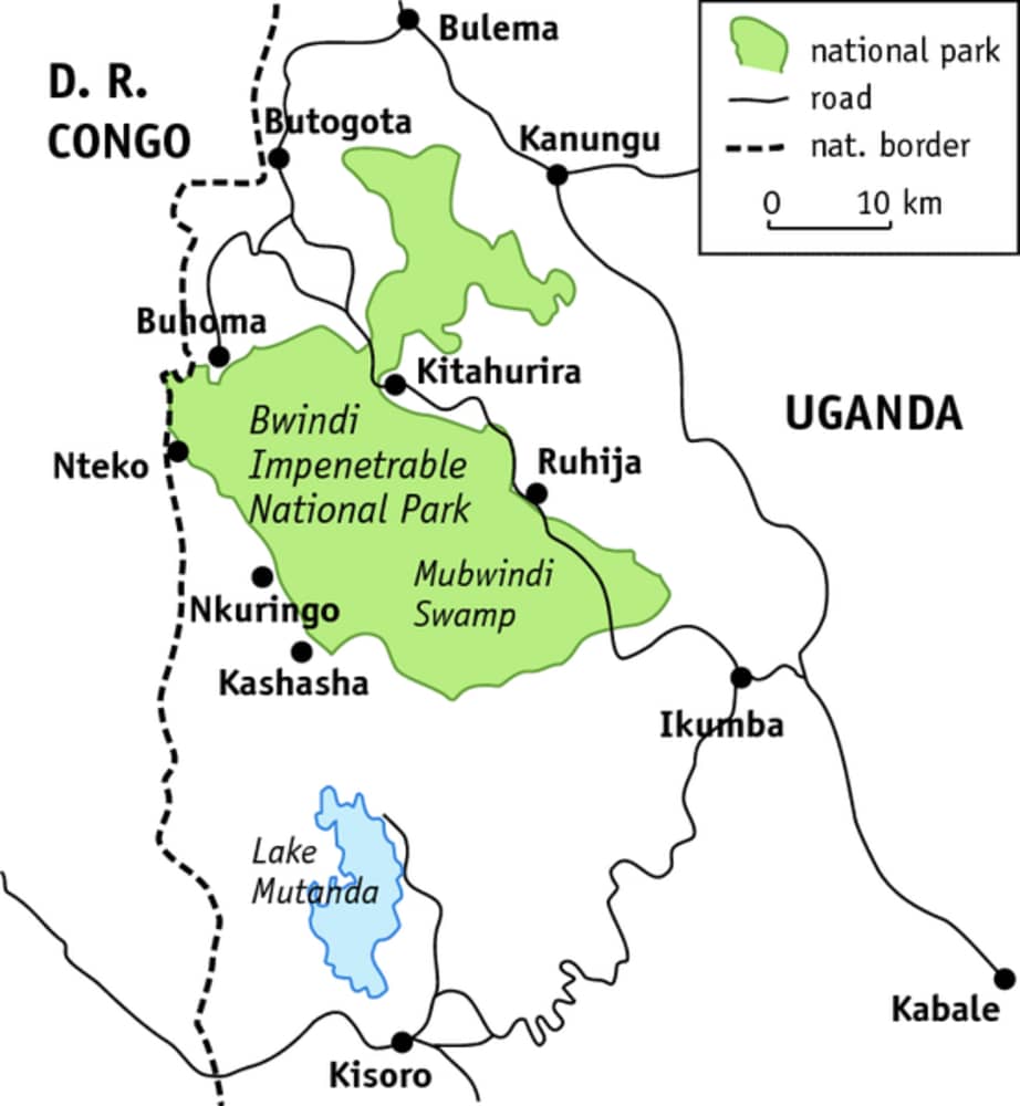
Bwindi Impenetrable National Park is located in southwestern Uganda, spanning parts of Kanungu, Kabale, and Kisoro districts near the borders of Rwanda and the Democratic Republic of Congo.
Positioned along the edge of the Albertine Rift Valley, Bwindi lies within one of Africa’s most biologically rich regions.
Its dramatic landscapes, ancient ecosystems, and exceptional species diversity make it one of the continent’s most important conservation areas.
1. Terrain
Bwindi’s terrain is rugged, steep, and deeply dissected by valleys and ridges, giving rise to its name “Impenetrable.”
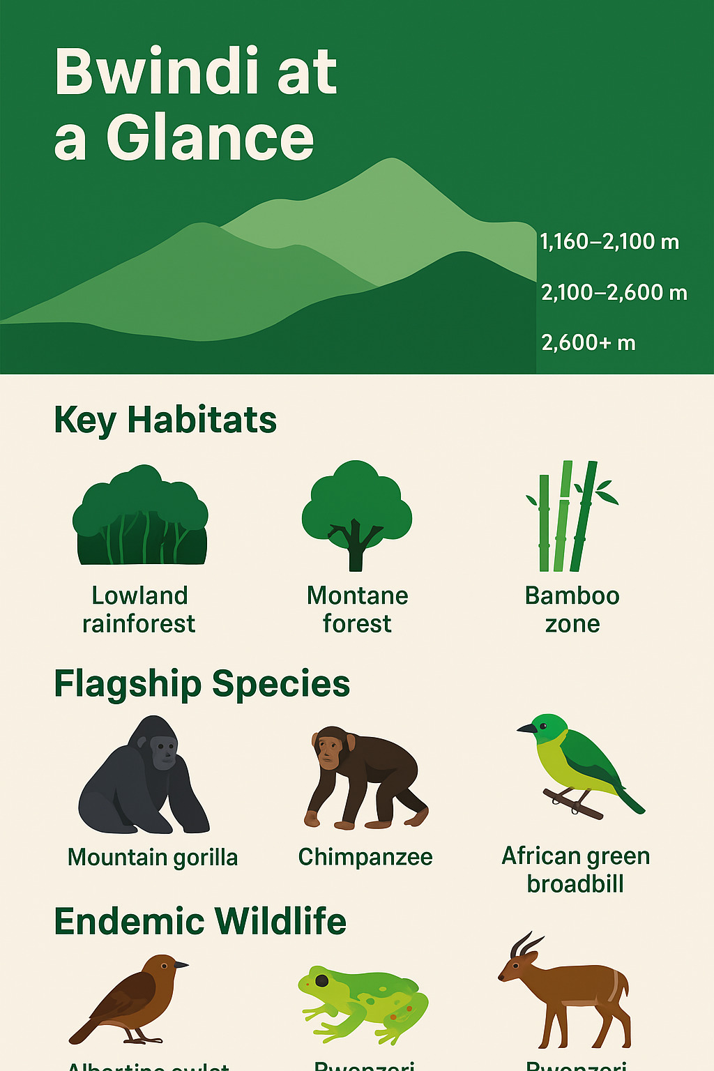
The park covers approximately 321 km² and ranges in elevation from about 1,160 meters to over 2,600 meters above sea level.
This wide altitudinal gradient creates a variety of microclimates, from warm lowland forest zones to cool montane habitats.
Frequent mist, high rainfall, and thick undergrowth make movement challenging, which is why navigation tools such as the Bwindi Impenetrable Forest Map are essential for trekkers and researchers alike.
Numerous rivers and streams originate in Bwindi, making it an important water catchment area for surrounding communities.
2. Flora
Bwindi is one of the most botanically diverse forests in East Africa.
The park hosts over 220 tree species and more than 100 species of ferns, many of which are endemic to the Albertine Rift.
The vegetation is a complex mosaic of lowland rainforest, montane forest, bamboo zones, and swamp vegetation, shaped by changes in altitude and rainfall.
Towering hardwood trees form dense canopies, while mosses, vines, orchids, and medicinal plants thrive beneath.
This ancient forest is believed to have survived the last Ice Age, making it a living museum of plant evolution and a critical refuge for rare flora.
3. Fauna
Bwindi’s biodiversity is globally renowned.
Most famously, it is home to over 460 mountain gorillas, making it the single most important stronghold for this critically endangered species.
In addition to gorillas, Bwindi supports populations of chimpanzees, forest elephants, L’Hoest’s monkeys, and numerous small mammals.
Birdlife is equally remarkable, with 350+ bird species, including 23 Albertine Rift endemics.
One of the park’s flagship species is the rare African green broadbill, a must-see for birdwatchers.
Reptiles, amphibians, and countless insect species further contribute to Bwindi’s status as a biodiversity hotspot.
Together, Bwindi’s unique geography and extraordinary biodiversity explain why it is both a UNESCO World Heritage Site and one of Africa’s most treasured natural landscapes.
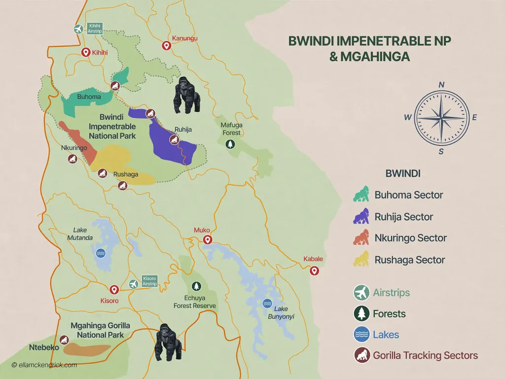
Detailed Bwindi Impenetrable Forest Map Breakdown
The Bwindi Impenetrable Forest Map is the core planning tool for navigating one of Africa’s most complex rainforest ecosystems.
Due to the park’s dense vegetation, steep terrain, and limited internal road network, understanding the map is essential for gorilla trekking, birding, research, and logistics.
This section breaks down the map into its most important components, explaining how each feature helps visitors, guides, and conservation teams move safely and efficiently within the park.
Overall Map Structure: Boundaries, Roads, and Drainage
At a glance, the Bwindi map clearly outlines the official park boundaries, enclosing approximately 321 km² of protected rainforest.
These boundaries separate the national park from surrounding community lands, tea plantations, and villages, making them critical for conservation enforcement and visitor orientation.
The road network shown on the map is sparse inside the park itself, reflecting Bwindi’s protected status.
Most roads run around the forest rather than through it, connecting key access towns and trekking sectors.
These include rough murram roads linking Buhoma, Ruhija, Rushaga, and Nkuringo, which are essential for planning travel times and selecting accommodation.
Equally important is the drainage system.
The map highlights rivers and streams that originate within Bwindi’s highlands, including the Ivi River, one of the park’s major waterways.
These rivers flow outward to surrounding regions, reinforcing Bwindi’s role as a vital water catchment area.
Drainage lines also help trekkers anticipate steep valleys and slippery sections along forest trails.
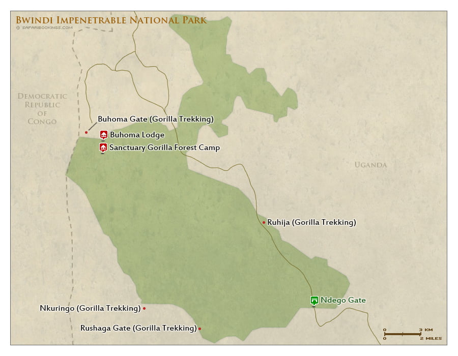
Bwindi’s Gorilla Trekking Sectors on the Map
The Bwindi Impenetrable Forest Map divides the park into four main gorilla trekking sectors—Buhoma, Ruhija, Rushaga, and Nkuringo.
Each sector has distinct terrain, access routes, trekking difficulty, and wildlife highlights.
Understanding these sectors on the map helps visitors choose the best experience based on fitness level, interests, and travel logistics.
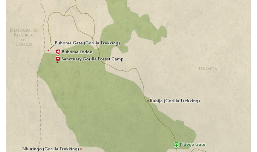
Buhoma Sector (North)
Buhoma, located in the northern part of Bwindi, is the most established and easily accessible trekking sector, especially for travelers arriving from Queen Elizabeth National Park.
On the map, Buhoma is marked by well-defined access roads, clear trail networks, and a concentration of lodges near the park boundary.
This sector is ideal for first-time gorilla trekkers.
Trails here are generally shorter and less steep compared to southern sectors, though the forest remains dense.
The map highlights multiple trailheads radiating from the Buhoma ranger station, making navigation straightforward.
Mini-map highlights:
-
Main access road from Kihihi and Ishasha
-
Buhoma park headquarters
-
River crossings and loop trails
Permit & trek info:
-
Gorilla permits are issued at the Buhoma ranger station
-
Average trek duration: 2–4 hours
-
Suitable for moderate fitness levels
Buhoma also has the widest range of lodges, camps, and community walks, clearly marked on the map, making it a popular and convenient base.
Ruhija Sector (East)
The Ruhija sector lies in the eastern highlands of Bwindi and is clearly identified on the map by its higher elevation contours.
Sitting between 2,300 and 2,600 meters above sea level, Ruhija offers cooler temperatures and expansive forest views.
Ruhija is particularly famous for birding, with the map highlighting nearby swamps and forest edges where Albertine Rift endemics are often spotted.
Elevation profiles on the map show steeper climbs, but trails are well spaced and less crowded.
Mini-map highlights:
-
Elevation contours and ridgelines
-
Birding hotspots and swamp zones
-
Connecting road from Kabale
Permit & trek info:
-
Permits issued at Ruhija ranger post
-
Average trek duration: 3–5 hours
-
Moderate to challenging due to altitude
This sector suits travelers seeking quieter treks, birdwatching, and scenic forest landscapes.
Rushaga Sector (South)
Rushaga, located in southern Bwindi, is the most extensive trekking sector on the map.
It hosts the largest number of habituated gorilla families, which increases permit availability and trekking options.
The map shows a dense network of trails spreading across varied terrain—ridges, valleys, and riverine forest—making Rushaga suitable for both short and long treks. Trek difficulty levels vary widely, and the map helps guides assign groups based on fitness.
Mini-map highlights:
-
Multiple gorilla family ranges
-
Road access from Kisoro
-
River valleys and steep slopes
Permit & trek info:
-
Permits available at Rushaga headquarters
-
Average trek duration: 2–6 hours
-
Options range from easy to strenuous
Rushaga is also the main sector for gorilla habituation experiences, a detail often noted on advanced trekking maps.
Nkuringo Sector (Southwest)
The Nkuringo sector, positioned in the southwestern corner of Bwindi, is known for its dramatic topography.
On the map, tightly packed contour lines immediately signal steep and demanding hikes.
Treks here are physically challenging but incredibly rewarding, offering panoramic views toward the Virunga Volcanoes and deep forest valleys.
The map emphasizes safety features such as designated trails, rest points, and ranger coverage.
Mini-map highlights:
-
Steep elevation gradients
-
Scenic viewpoints
-
Limited but clear trail routes
Permit & trek info:
-
Permits issued at Nkuringo ranger station
-
Average trek duration: 4–6+ hours
-
Best for fit, experienced hikers
Safety tips (map-based):
-
Study elevation profiles before trekking
-
Follow marked trails only
-
Use porters for steep descents
Choosing the Right Sector Using the Map
By comparing access roads, elevation, trail density, and wildlife zones on the Bwindi Impenetrable Forest Map, visitors can confidently select the sector that best matches their expectations—whether that’s an easy first trek in Buhoma, birding in Ruhija, variety in Rushaga, or adventure in Nkuringo.